


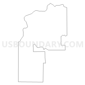
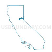
Voting District 40280, Nevada County, California
About
Outline
Summary
| Unique Area Identifier | 535696 |
| Name | Voting District 40280 |
| County | Nevada County |
| State | California |
| Area (square miles) | 34.62 |
| Land Area (square miles) | 33.64 |
| Water Area (square miles) | 0.99 |
| % of Land Area | 97.15 |
| % of Water Area | 2.85 |
| Latitude of the Internal Point | 39.22474540 |
| Longtitude of the Internal Point | -121.22078130 |
Maps


Graphs
Select a template below for downloading or customizing gragh for Voting District 40280, Nevada County, California


Neighbors
Neighoring Voting District (by Name) Neighboring Voting District on the Map
- Voting District 40250, Nevada County, CA
- Voting District 40255, Nevada County, CA
- Voting District 40265, Nevada County, CA
- Voting District 50055, Yuba County, CA
- Voting District 50060, Yuba County, CA
Top 10 Neighboring County Subdivision (by Population) Neighboring County Subdivision on the Map
- Grass Valley CCD, Nevada County, CA (66,614)
- Nevada City CCD, Nevada County, CA (15,238)
- Marysville Northeast CCD, Yuba County, CA (7,357)
- East Yuba-Beale AFB CCD, Yuba County, CA (4,520)
Top 10 Neighboring Place (by Population) Neighboring Place on the Map
Top 10 Neighboring Elementary School District (by Population) Neighboring Elementary School District on the Map
- Grass Valley Elementary School District, CA (25,100)
- Pleasant Valley Elementary School District, CA (7,793)
- Wheatland Elementary School District, CA (7,225)
- Ready Springs Union Elementary School District, CA (5,097)
- Twin Ridges Elementary School District, CA (2,544)
Top 10 Neighboring Secondary School District (by Population) Neighboring Secondary School District on the Map
- Nevada Joint Union High School District, CA (81,863)
- Wheatland Union High School District, CA (10,944)
Top 10 Neighboring Unified School District (by Population) Neighboring Unified School District on the Map
Top 10 Neighboring State Legislative District Lower Chamber (by Population) Neighboring State Legislative District Lower Chamber on the Map
Top 10 Neighboring State Legislative District Upper Chamber (by Population) Neighboring State Legislative District Upper Chamber on the Map
Top 10 Neighboring 111th Congressional District (by Population) Neighboring 111th Congressional District on the Map
Top 10 Neighboring Census Tract (by Population) Neighboring Census Tract on the Map
- Census Tract 410, Yuba County, CA (7,357)
- Census Tract 4.02, Nevada County, CA (6,926)
- Census Tract 4.01, Nevada County, CA (5,744)
- Census Tract 9, Nevada County, CA (4,348)
- Census Tract 409.01, Yuba County, CA (2,783)
- Census Tract 2, Nevada County, CA (2,700)
Top 10 Neighboring 5-Digit ZIP Code Tabulation Area (by Population) Neighboring 5-Digit ZIP Code Tabulation Area on the Map
- 95949, CA (19,741)
- 95959, CA (17,838)
- 95946, CA (9,790)
- 95918, CA (2,339)
- 95975, CA (1,769)
- 95977, CA (1,678)
- 95960, CA (796)